Nottingham's Lost Railway Heritage
The Great Central Railway
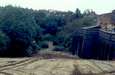
The ![[Img: Inside the GCR tunnels]](../notts-gcr/index.jpg) GCR London Extension ran like an arrow North to South through and under Nottingham city centre. There remain tunnels, bridges and viaducts for much of the way. We looked at the remains of the GCR's Weekday Cross viaducts with Huntingdon Street and Sherwood Rise tunnels.
GCR London Extension ran like an arrow North to South through and under Nottingham city centre. There remain tunnels, bridges and viaducts for much of the way. We looked at the remains of the GCR's Weekday Cross viaducts with Huntingdon Street and Sherwood Rise tunnels.
The Great Northern Railway
The Great Northern was in a continual battle with the Midland, for whom the Nottinghamshire coal traffic was "home turf". The Midland had been formed as a result of a meeting in the Sun Inn in Eastwood in 1844. The intense railway development by both companies has left many remains today.
The Nottingham Suburban Railway
From Trent Lane Junction
(SK591394)
on the GNR Notts-Grantham line, to Daybrook
(SK579445)
on the GN's original line from Netherfield to Basford, the
![]() Nottingham Suburban Railway ran through hilly suburbs with 1,048 yards of tunnels
and a climb of over 200 feet in 3 ¾ miles. Stations were at Thorneywood
(SK591409),
St. Ann's Well
(SK588418),
and Sherwood.
Nottingham Suburban Railway ran through hilly suburbs with 1,048 yards of tunnels
and a climb of over 200 feet in 3 ¾ miles. Stations were at Thorneywood
(SK591409),
St. Ann's Well
(SK588418),
and Sherwood.
Conceived in 1886, before the opening of the more-direct GCR and before the advent of direct city centre tram services, it lasted into the 1930s (just) for passenger services, and the final section was not closed until 1954 (last freight 1951). Its route was only built upon relatively recently (1980s/90s). Much of its impressive brickwork above and below ground had already been redeveloped into flats or gardens by 1999, but much also remained. The Suburban Railway also served an extensive brickworks at Mapperley via a narrow gauge rope-worked incline.

Via GNR to Derby
The Great Northern line from Bulwell ran via Kimberley, Ilkeston, Derby Friargate and Mickleover to join the Derby-Crewe line.
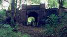
GNR at Kimberley
 Kimberley GNR station on the Derby line survives today. The buildings
are occupied by business, as is the recently-cleared goods yard. The long
cutting and tunnel towards Watnall were recently (1999) infilled and used
for housing. But the station area and the still-extant section of the
railway cutting are a council heritage site and nature reserve.
Map Ref SK499448
Kimberley GNR station on the Derby line survives today. The buildings
are occupied by business, as is the recently-cleared goods yard. The long
cutting and tunnel towards Watnall were recently (1999) infilled and used
for housing. But the station area and the still-extant section of the
railway cutting are a council heritage site and nature reserve.
Map Ref SK499448
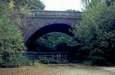
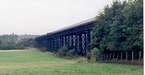
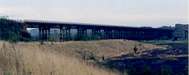
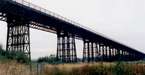
Bennerley Viaduct
Bennerley Viaduct, opened in 1878, carried the Great Northern Railway across the Erewash Valley between Awsworth and Ilkeston, en route from Basford (Nottingham) to Derby and Uttoxeter. Although the route is now closed, this listed structure remains, striding above the Midland's Erewash Valley line. Map Ref SK474439

More pics on
IlkCam, Lawrence's Eastwood and ![]() many other places
many other places
Ilkeston GNR
From Bennerley the line ran through Ilkeston, where the trackbed nowadays forms Cotmanhay Linear Park. Nowadays on the main GNR line, there is a police station blocking the trackbed next to the infilled Heanor road overbridge.
The GNR's Ilkeston Junction was a meeting point for branches north and southwards. North was the line to Heanor GNR, which also served pits including Shipley and Woodside Collieries (the latter home in the 1960s of an ex-Mersey Railway condensing tank loco). Photo-report continues.
Coming in from the south was the GNR connection from the Midland via Stanton Ironworks. In 1978 I walked this branch but haven't yet found my pictures.
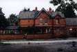
Derby Friargate GNR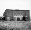
The Notts-Derby line meandered across Derbyshire farmland. I visited Derby Friargate, the major passenger station on the line, in 1977 with a compact 120 folding camera. Back then there was a bit more to see than today, but the station is still there in 2007. Photo-report continues.
Midland Railway
The Midland's 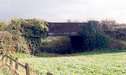 Erewash Valley line was the key to its coal fortunes. Striking north to south midway between Nottingham and Derby, it was ideally placed to capture coal traffic from both centres - which it did via a network of branches and feeder connections. Many of them were in direct competition with corresponding lines on the GNR system, sometimes only tens of feet apart from each other.
The Cromford Canal
Langley Mill and Cromford main line
Before the railways came, the
![]() Cromford Canal connected Cromford to the
Cromford Canal connected Cromford to the
![]() Erewash Canal at Pye Bridge. In its 14½ miles it had three
aqueducts, four tunnels and 14 locks, including a two-mile tunnel
under Butterley near Ripley to reach the Golden Valley.
Map Ref SK421513
Erewash Canal at Pye Bridge. In its 14½ miles it had three
aqueducts, four tunnels and 14 locks, including a two-mile tunnel
under Butterley near Ripley to reach the Golden Valley.
Map Ref SK421513
Pinxton Canal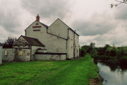
At Ironville the Cromford sent a branch northwards to Pinxton. There it had a wharf to receive traffic carted from Mansfield and area such as Mansfield porcelain. It connected with the Mansfield and Pinxton horse tramway which also provided a passenger service. Tickets for the tram were bought at the Boat Inn. Photo-report continues.
Butterley Canal Tunnel
 On the Cromford arm, the canal bed down to Ironville still exists, including the locks at Ironville. Both tramways aboveground and a wharf and crane lift deep inside the tunnel connected the canal to The Butterley Company's ironworks above. Butterley, as
well as building many bridges from the 1800s to the present day, also
provided the roof ironwork for the Midland's St. Pancras Station. See the
Friends Of Cromford Canal
pictures
from inside the tunnel taken on an inspection in 1979.
On the Cromford arm, the canal bed down to Ironville still exists, including the locks at Ironville. Both tramways aboveground and a wharf and crane lift deep inside the tunnel connected the canal to The Butterley Company's ironworks above. Butterley, as
well as building many bridges from the 1800s to the present day, also
provided the roof ironwork for the Midland's St. Pancras Station. See the
Friends Of Cromford Canal
pictures
from inside the tunnel taken on an inspection in 1979.
And if having a wharf inside a canal tunnel isn't unusual enough, at Worsley near Manchester there is an entire underground canal system, built by the Duke of Bridgewater to serve his collieries - presumably it saved hauling the coal to the surface and then down the hill again! 50 miles of tunnel on four levels, including an underground inclined canal plane - a staggering enterprise. If that could be re-opened one day, maybe the Butterley tunnel might be too ... ?
Relevant Links
- Nottingham Rail shows in photographs how the railways of Nottingham and surrounding areas have changed over the last 100 years, including many not mentioned here.
- Nottingham GC and GN pictures from the 1950s (via archive.org - most pics sadly offline now)
- Shipley Park railways and tramways (via archive.org)
- Canals, Rivers and Viaducts and other local history in the Eastwood area, by Nigel Harrison.
- Nottingham Railway Archaeology in pictures.
 As well as the links in the text above, there's almost certainly something on Google
about the subject, too.
As well as the links in the text above, there's almost certainly something on Google
about the subject, too.
Bibliography
- Forgotten Railways: The East Midlands
- By P. Howard Anderson, pub. David & Charles 1973, ISBN 0 7153 6094 9
- A Regional History of the Railways of Great Britain: Volume 9 The East Midlands
- By Robin Leleux, pub. David & Charles 1976, revised 1984 for Book Club Associates, ISBN 0 946537 06 2
- British Railways Pre-Grouping Atlas and Gazetteer
- Pub. Ian Allan Ltd various dates, ISBN 0 7110 0320 3